← FOREST WATCH

The shape of the land

EXPERIMENTAL · KOH PHANGAN · 18 POSSIBLE CHANGE LOCATIONS · 31.2 HA

This page looks at the ground around each possible forest-change location: how high and how steep it is, and where water leaving it would run. It can help decide which locations to visit together and what to look for. The valley lines are modelled, not surveyed, and nothing here has been checked on the ground.

What this adds

The priority list treats the 18 locations as separate points. Here they are placed in the landscape: which sit on a ridge, a hillside or a valley line, and which the model routes towards the same outlet.

What it cannot tell you

Whether a stream actually exists at a location, how much water it carries, or whether soil is being lost. The elevation data has 30 m cells and, under forest, follows the tree tops rather than the ground. A steep slope or a valley line is a reason to look, not a finding.

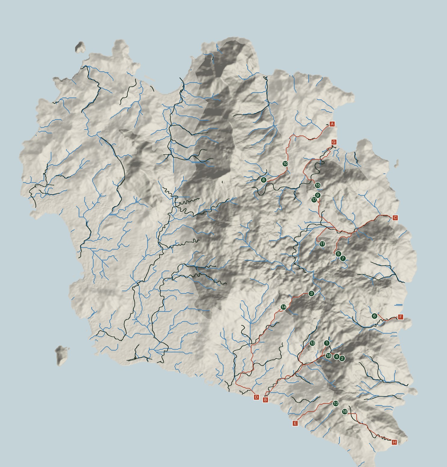
Relief map of Koh Phangan showing the 18 numbered possible-change locations, modelled valley lines, mapped rivers, and the path water would take from each location to the sea

On a small screen this shows only the part of the island where the locations are, so the numbers can be read.

Open the whole map at full size

Possible-change locationModelled valley lineMapped river or streamModelled path of water to the seaWhere it reaches the sea

Land outside the mapped park boundary is shown paler. Where a mapped river and a modelled valley line run side by side, the model agrees with the map; where a modelled line has no mapped river beside it, either the river is unmapped or the model is wrong.

Where the modelled flow paths lead

7 modelled drainage groups

Following the modelled flow paths from each location towards the coast groups the 18 locations by their modelled outlet. These groups may help plan field visits, although access and actual river connections need to be checked on the ground.

Outlet group B/D — near Khlong Bang Nam Khem
The model routes these locations to 2 separate coastal outlets (B and D) about 300 m apart. They may belong to the same river system in reality, but this has not been verified.
locations1, 2, 3, 4, 13, 14, 18
how many7
combined area13.18 ha
Outlet group A
No named waterway is mapped near this outlet.
locations8, 10
how many2
combined area8.34 ha
Outlet group C — near Khlong Than Sadet
locations5, 7, 9, 11, 17
how many5
combined area6.16 ha
Outlet group E
No named waterway is mapped near this outlet.
locations12
how many1
combined area1.38 ha
Outlet group F — near Khlong Ao Hat Yang
locations6
how many1
combined area0.79 ha
Outlet group G — near Khlong Ta Pan
locations15
how many1
combined area0.72 ha
Outlet group H
No named waterway is mapped near this outlet.
locations16
how many1
combined area0.68 ha

Each location

18 locations · numbered in visit order, as in the priority list. On the map, 10 to 18 are the small on-hold dots

Elevation is estimated from a 30 m surface model; under forest it may reflect the canopy rather than ground level. Slope is the typical slope across the location (the median), with the steepest part in brackets.

Modelled upstream land is the area of land that the terrain model routes through the location. It is not a measure of rainfall, water volume or stream flow. A larger area suggests that more of the surrounding terrain contributes to that point in the model.

1
Sits on: valley line
Outlet group B/D — near Khlong Bang Nam Khem
area5.39 ha
elevation300 m
slope19° (up to 35°)
upstream land31.3 ha
to a valley lineon one
2
Sits on: valley line
Outlet group B/D — near Khlong Bang Nam Khem
area1.72 ha
elevation386 m
slope34° (up to 37°)
upstream land11.5 ha
to a valley lineon one
3
Sits on: ridge or upper slope
Outlet group B/D — near Khlong Bang Nam Khem
area1.54 ha
elevation344 m
slope11° (up to 14°)
upstream land0.4 ha
to a valley line210 m
4
Sits on: valley line
Outlet group B/D — near Khlong Bang Nam Khem
area1.49 ha
elevation325 m
slope30° (up to 32°)
upstream land17.2 ha
to a valley lineon one
5
Sits on: hillside
Outlet group C — near Khlong Than Sadet
area1.48 ha
elevation263 m
slope8° (up to 11°)
upstream land6.8 ha
to a valley line30 m
6
Sits on: valley line
Outlet group F — near Khlong Ao Hat Yang
area0.79 ha
elevation200 m
slope10° (up to 13°)
upstream land24.9 ha
to a valley lineon one
7
Sits on: ridge or upper slope
Outlet group C — near Khlong Than Sadet
area0.72 ha
elevation273 m
slope8° (up to 13°)
upstream land0.2 ha
to a valley line192 m
8
Sits on: hillside
Outlet group A
area0.93 ha
elevation302 m
slope15° (up to 19°)
upstream land3.2 ha
to a valley line102 m
9
Sits on: ridge or upper slope
Outlet group C — near Khlong Than Sadet
area0.7 ha
elevation245 m
slope13° (up to 21°)
upstream land0.3 ha
to a valley line307 m
10
Sits on: valley line
Outlet group A
area7.41 ha
elevation169 m
slope14° (up to 26°)
upstream land246.4 ha
to a valley lineon one
11
Sits on: hillside
Outlet group C — near Khlong Than Sadet
area2.61 ha
elevation194 m
slope13° (up to 20°)
upstream land4.0 ha
to a valley line252 m
12
Sits on: hillside
Outlet group E
area1.38 ha
elevation404 m
slope9° (up to 12°)
upstream land3.6 ha
to a valley line325 m
13
Sits on: ridge or upper slope
Outlet group B/D — near Khlong Bang Nam Khem
area1.34 ha
elevation277 m
slope22° (up to 30°)
upstream land0.5 ha
to a valley line345 m
14
Sits on: hillside
Outlet group B/D — near Khlong Bang Nam Khem
area1.05 ha
elevation259 m
slope23° (up to 34°)
upstream land2.8 ha
to a valley line157 m
15
Sits on: valley line
Outlet group G — near Khlong Ta Pan
area0.72 ha
elevation216 m
slope16° (up to 19°)
upstream land22.1 ha
to a valley lineon one
16
Sits on: ridge or upper slope
Outlet group H
area0.68 ha
elevation402 m
slope9° (up to 16°)
upstream land0.5 ha
to a valley line360 m
17
Sits on: ridge or upper slope
Outlet group C — near Khlong Than Sadet
area0.65 ha
elevation246 m
slope10° (up to 23°)
upstream land0.7 ha
to a valley line187 m
18
Sits on: valley line
Outlet group B/D — near Khlong Bang Nam Khem
area0.65 ha
elevation207 m
slope25° (up to 33°)
upstream land61.2 ha
to a valley lineon one

How well does the model match mapped waterways?

We compared the modelled valley lines with 77 km of rivers and streams mapped in OpenStreetMap. These waterways were not used to build the model.

63% of the mapped waterway length lies within 60 metres of a modelled line, compared with 24% of all land.

This is an encouraging indication that the model captures broad valley patterns in the landscape. It gives a useful starting point for identifying where streams or drainage channels may be found.

The comparison does not confirm the exact location of individual channels. Some waterways may be missing from the map, and the elevation data cannot always distinguish a real stream from a modelled downhill route.

In practice, the model helps identify places worth checking in the field. A visit can establish whether a channel exists and whether the modelled route matches the terrain. A location marked “valley line” is a place to look for a channel, not a place where one is known to exist.

What to check on the ground

At a location marked “valley line”, or on a steep slope:

“No channel here” is a useful answer. It tells us where the model was wrong.